
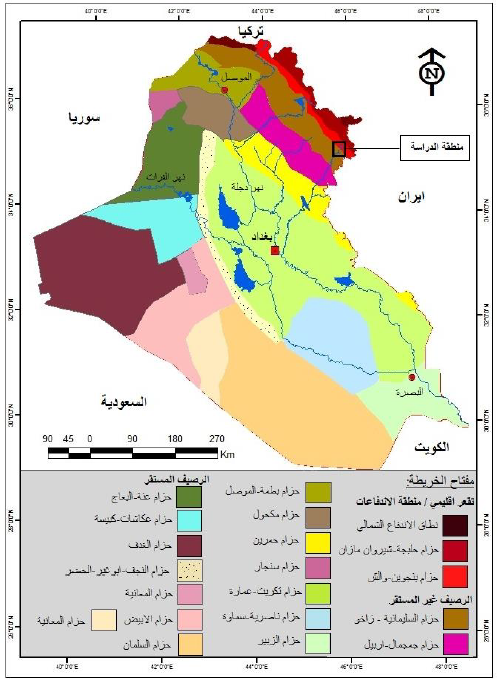
جيومورفولوجية منطقة دربندخان شرقي العراق
أطروحة مقدمة
إلى مجلس كلية التربية والعلوم الإنسانية - جامعة ديالى
كجزء من متطلبات
نيل درجة دكتوراه فلسفة في الجغرافية الطبيعية
من قبل الطالب
ماهر سلمان مالك
إشراف
أ.د. منذر علي طه الخالدي
1438هـ - 2017م
 |
جيومورفولوجية منطقة دربندخان شرقي العراق


Geomorphological of Darbendikhan region/Eastern of Iraq
A thesis
Submitted by
Maher Salman Malik
The Council of College of Education for Human Sciences Diyala university as a Partial Fulfillment of the Ph .D Degree in physical Geography
Supervised By
Prof. Munther Ali Taha AL-khaldy (Ph.D.)
2017 A.D 1438 A.H

Abstract
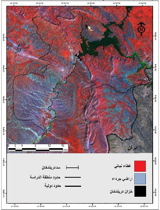
The study of (Geomorphological of Darbandikhan region/ Eastern of Iraq) was studied through extensive fieldwork and office work, as well as relying on satellite imagery (Land Sat TM5),( Land Sat LC8), as well as basic maps and data obtained from the official departments. And the maps used in the study using two programs (ERDAS IMAGINE 9.2), (Arc GIS 10.3). The study reached on many conclusions as follow:
1- The activation of morphoclimatic process according to extreme of temperatures, rainfall, thus the Mechanical erosion activation in drought years and cut off rains season while the process of substances movement increase in wet seasons specially the mountains of kithraker, kolan, Barda Dokin, Kola, Shafa Rish, Zamakan, and on the hills less than (1000m) above sea level in which locates in south and south-west of the study area and at east of Darbandikhan dam which increases of rocky sediments so it facilitates the process of transfer it by morphodynamic processes.
2- The activation of water erosion processes. So it resulted patterns presented by sheet wash erosion which conformed a ratio 16% from the area of region (538k2) it contains on major plain parts from Diwana basin in the middle of west region along Diyala river because of decrease slope factor in it. While the rills erosion have 36% it prevails in (NE) from the study area, and a narrows bar parallel diyala river extend in the middle of the region. Whereas the groove erosion was 48% it was gathering in the east of region within mountain chains and hills area in north and (SW) of the study area.
3- The area of the study was in the first five categories according to the Bergsma equation for the intensity of the sculpture. The area of the first category was non- erosion (40.3 km2), the second type was light erosion (217.9 km2), the third class was medium erosion, it reached 234.95 km2, High (44.22 km 2), and finally classified as very high erosion area (0.93 km 2)
4- geomorphological map that depends on space images in which used in the study there are three geomorphological units are (structural, erosional, depositional)the erosional unite has a first rank with (57.1%) than structural unite with a ratio (31.77%) This indicates the region exposed for c geomorphological processes very activated. Sothat the major geomorphological used in the study region is inherited shapes belong to ancient climatical changes and the present climate has a role in developing these units.
5- The earth sensitive degree connects with geomorphological processes activity in the region so the study region divided into six categories the first second, third, forth category few and intermediate sensitive an area (254k2) with ratio (47%) represented in the south of the study region along Diyala river and north of Darbandikhan city, while the two categories the most in tensitive have (53%) fin which they represented the mountains of the region in particular in east part.
6- The space images was used to became very vital to uncover from the environmental ruin and drawing maps for ecological hazards demands for experience to isolate the categories of sensitive degrees for its connection by a groups of layers depending on Holand classification (I.T.C).
The study concluded was theorical frame and fore chapters, the first was about the evaluation of controlling factors in geomorphological processes. where as the second chapter, it came with two sections and the forth chapter concerned with environmental features, and the final chapter, is about observation and morphological evaluation, for the study region and then conclusions and recomandations, sources, adition and the abstract in English language.


0 تعليقات
شكرا لتعليقك .. سيتم الرد عليكم في اقرب وقت ممكن .
كوكب المنى