
استخدام تقنيات الاستشعار عن بعد ونظم المعلومات
الجغرافية
في تقدير ظاهرة التصحر في سهل بنغازي
د. ريم علي محمود الزردومي
عضو هيأة تدريس كلية الصحة العامة - جامعة بنغازي
عضو الاتحاد الدولي للبيئة والتنمية المستدامة
د. أحمد محمد جعودة
أستاذ مساعد - كلية الآداب
قسم الجغرافيا - جامعة بنغا زي

مجلة كلية الآداب - جامعة بنغازي - العدد 48 - أبريل 2020م - ص ص. 162 - 180:
الملخص
تعد دراسة التصحر وقياس التدهور في الخصائص الحيوية، وتدك درجاته من الدراسات المهمة اليوم لما تعانيه العديد من دول العالم من تفاقم مشكلة التصحر، وزادة معدلات خطورته على حياة الإنسان ومستقبله القرب. من هنا جاعت هذه الدراسة لتتناول موضوع التصحر بمنطقة سهل بنغازي، وقياس حجم الدهور الحاصل، إلى جانب قياس درجاته، والوقوف على الأسباب التي ساعت على تطور المشكلة بمنطقة الدراسة.
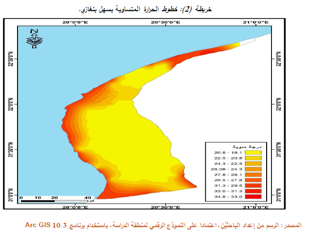
واعتمدت الدرسة على تقنيات الاستشعار عن بعد ونظم المعلومات الجغرافية في تطيل البيانات، من خلال الاعتماد على صورتين فضائيتين في فتزت مختلفة (1984 ،2019) لرعد حجم المشكلة، ومعرفة أسبابها، وتحديد أكثر المناطق المعرضة لتصحر. حث اعتمد على مجموعة من المعايير التي تحدد درجات التصحر، ومنها: (نموذج الارتفاع الرقمي DEM_ درجة الحرر:_ الأمطار_ التدخلات البشرة متمثلة في العمر_زحف الرمال_ الأرضي الملحية_ النبات)، بالإضافة إلى تحديد درجات خطورة التصحر من خلال تطيل الصور الفضائية لمنطقة الدراسة.
الكلمات المفتاحية: التصحر - درجات التصحر - سهل بنغازي - نظم المعلومات
الجغرافية - الاستشعار عن بعد.
Using Remote Sensing and GIS Techniques in Estimating Desertification Phenomenon in Benghazi Plain
Abstract: The study of desertification and measuring degradation in the biological characteristics and determining its degrees are important studies today because many countries of the world are suffering from the aggravation of desertification problem and increase the rates of its risk on the human life and its near future.
Hence, this study came to address the issue of desertification in the plain of Benghazi and measure the size of deterioration in addition to measuring its degrees and identify the reasons that helped to develop the problem in the study area.
The study relied on remote sensing and GIS techniques to analyze
the data by relying on two space images in different periods (1984, 2019) to
monitor the size of the problem, find out its causes and identify the areas
most exposed to desertification. A set of criteria that determine the degrees
of desertification including (digital elevation model “DEM” - temperature -
rainfall - human interventions represented in urbanization - sand encroachment
- salt land - plant) in addition to determining the grades of
desertification risk through analyzing the space images of the study
area.
Keywords:
Desertification - Degrees of Desertification - Plain of Benghazi - GIS - Remote
Sensing.


0 تعليقات
شكرا لتعليقك .. سيتم الرد عليكم في اقرب وقت ممكن .
كوكب المنى