
مظاهر التصحر و تأثيرها على الواقع الزراعي في محافظة ذي قار
رسالة تقدم بها
حيدر عبد المحسن كاظم العسكري
إلى مجلس كلیة الآداب - جامعة ذي قار
وھي جزء من متطلبات نیل شھادة ماجستیر آداب في الجغرافیة الطبیعیة
إشراف
الأستاذ المساعد الدكتور
عبد الرزاق خیون خضیر ال محیمید
1437هـ - 2016م


المستخلص:
تهدف الدراسة إلى الكشف عن (مظاهر التصحر وتأثيرها على الواقع الزراعي في محافظة ذي قار) وتحديد مناطق توزيعها المكاني وتصنيفها، إذ تطرقت الدراسة إلى مفهوم التصحر ودرجاته وأهم مظاهره، فضلاً عن طبيعة الوضع الزراعي في منطقة الدراسة، وقد تم التوصل إلى أن منطقة الدراسة تعاني من مشكلة التصحر وما ينجم عن سيادة مظاهرها من تأثيرات أسهمت في تضرر المساحات المزروعة وتناقص الإنتاج الزراعي.
كما شملت الدراسة أهم العوامل الطبيعية المساهمة في نشوء مظاهر التصحر في منطقة الدراسة، إذ تأتي في مقدمتها التركيب الجيولوجي والسطح وخصائص المناخ والظواهر المناخية وخصائص الموازنة المناخية والنبات الطبيعي وخصائص الموارد المائية والتربة، وقد تبين أن العوامل المذكورة آنفاً ساهمت في نشوء وتفاقم مشكلة التصحر في منطقة الدراسة سواء بصورة مباشرة أو غير مباشرة، كما تبين أن منطقة الدراسة تعاني عجزاً مائياً كبيراً وصل إلى (3497.3 مليمتر) وفي جميع الشهور حتى خلال الفصل المطير مما انعكس على خصائص الموارد المائية التي انخفضت مناسيبها بصورة عامة السطحية منها والجوفية.
وقد تناولت الدراسة أهم العوامل البشرية المساهمة في نشوء مظاهر التصحر والمتمثلة بأتباع الأساليب الخاطئة في العمليات الزراعية والنمو السكاني والزحف العمراني والرعي الجائر وغيرها، إذ ظهر من خلال الدراسة أن لجهل الفلاح وقلة معرفته بالاحتياجات المائية التي تتطلبها المحاصيل الزراعية، والإفراط في استخدام مياه الري مع قلة المبازل أو انعدامها إسهاماً في تقلص المساحات الزراعية نتيجة لتدهور خصائص التربة وقلة إنتاجيتها مما دفع بالمزارعين إلى تركها بوراً دون زراعة، كما تبين أن للنمو السكاني والذي بلغ معدله في منطقة الدراسة (2.9%) والزحف العمراني دوراً في زيادة الضغط على الأراضي الزراعية وتقلص المساحات الصالحة للزراعة وبالتالي تدهور مساحات واسعة منها وقلة إنتاجيتها وتعرضها للتصحر، فضلاً عن دور الرعي الجائر في تفاقم مشكلة التصحر من خلال تعرض المراعي الطبيعية إلى تلف الغطاء النباتي الطبيعي الواقي لها.
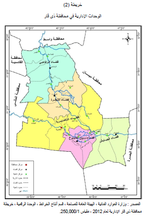
وقد تم دراسة التأثيرات الناجمة عن مظاهر التصحر وتوزيعها المكاني في منطقة الدراسة، والمتمثلة بالتأثيرات الناجمة عن مشكلة ملوحة التربة وتوزيعها المكاني في منطقة الدراسة، إذ تبين أن الترب في منطقة الدراسة على اختلاف أصنافها تعاني من مظهر التملح وبدرجات متفاوتة، وذلك بحسب طبيعة استعمال الأرض أو تركها بوراً وسوء استعمال مياه الري ومستوى المياه الجوفية وقربها من سطح الأرض، فضلاً عن أثر الملوحة في سيادة أنواع معينة من المحاصيل ذات القدرة على تحمل الملوحة العالية على حساب المحاصيل الحساسة للملوحة، كما تم التطرق إلى التأثيرات الناجمة عن مظهر التعرية الريحية. وتوزيعها المكاني في منطقة الدراسة، فقد أظهرت الدراسة أن لمظهر التعرية الريحية وما ينجم عنها من ظواهر الجو الغبارية تأثيرات كبيرة على خصائص التربة وإنتاجيتها في منطقة الدراسة، كما كشفت الدراسة ومن خلال تطبيق معادلة (F.A.O) أن المجموع السنوي للقابلية المناخية للتعرية الريحية بلغ في منطقة الدراسة (276.29) وبذلك تقع ضمن التعرية الشديدة جدا، كما أظهرت الدراسة أن هناك تبايناً فصلياً ومكانياً في كمية الدقائق التي تنقلها الرياح من الطبقة السطحية لتربة منطقة الدراسة تبعا لتباين القابلية المناخية للمنطقة، كما شملت الدراسة التأثيرات الناجمة عن حركة الكثبان الرملية وتوزيعها المكاني في المنطقة، إذ أظهرت الدراسة تحول مساحات واسعة من الأراضي الزراعية والمراعي في مناطق البطحاء والفجر والنصر وقلعة سكر إلى أراضي متصحرة بفعل زحف وحركة الكثبان الرملية، أذ بلغت مساحة الأراضي التي تعرضت لزحف وحركة الكثبان الرملية في منطقة الدراسة (162000 دونماً).
كما تناولت الدراسة أهم الوسائل التي يمكن أتباعها لمكافحة مظاهر التصحر، حيث تم التطرق إلى أهم الوسائل العلمية التقنية منها الاجتماعية والاقتصادية التي يمكن من خلالها مكافحة مظاهر التصحر والحد من تأثيراتها على الأراضي الزراعية في منطقة الدراسة.
The manifestations of desertification and its effect on the agriculturl reality in Dhi Qar
A Thesis submuted BY
Hayder Abd AL-Mohsin Kadhim AL-Askary
To council
Of the college of Arts University of
the Dhi Qar in partial fulfillment of the Requirements for the degree of master
of Arts in Geography
Supervised by
Assistant professor Dr.
Abdul Razak Khyoun Khudair AL
Mahimid
2016 A.D. - 1437 A.H

Abstract
The aim of this thesis is to detect the manifestations of desertification and their effects on the agricultural situation in Dhi-Qar governorate and determine the regions of their spatial distribution and classifications. This study has explained the concept, degrees, and manifestations of desertification and the agricultural status at the chosen area. It has been observed that a wide area of Dhi-Qar governorate is suffered from the problem of desertification which has harmed the agricultural lands and reduced the agricultural production.
This study has also showed the most important natural factors that cause the generation of manifestations of desertification in the selected region such as the geological structure, the surface, the features of climate, the climate phenomena, the climate balancing properties, the natural plant, the water resource characterisations, and the soil. It has been noticed that the aforementioned impacts are directly or indirectly participated and increased the problem of desertification in the study region. Moreover, it has been showed that the selected region is highly suffered from low water which is estimated by 3497.3 mm during the year including the raining season. This has reflected on the water resource characterisations and decreased both the overground and underground resources.
This thesis has addressed the most important human parameters that are participated in appearing the desertification such as the wrong procedures in agriculture, population growth, infrastructure increasing, overgrazing …etc. Consequently, in this study, it has been observed that the farmer has no taught, low knowledge with his water requirements for the agricultural crops and excess in using an irrigation water in the face of low number of stream of water. As a result, the soil has become unsuitable for agriculture which makes it uncultivated area. In addition, the population growth which is approximately 2.9% and the infrastructure increasing have negative role on the suitable areas for agriculture and their productions which cause deterioration of large areas that leads for desertification. Moreover, the overgrazing has increased the problem of desertification through suffering the natural pastures to damage their natural plant that is utilised to as protection cover.
In this study, it has been given the impacts that result form the manifestations of desertification and their spatial distribution in the chosen area such as soil salinity. It has been noted that all types of the soils are suffered from various degrees of the salinity. This refers to employing or ignoring the soil as well as the incorrect using of the water for agriculture and the level of groundwater and its approaching from the ground. Furthermore, the impact of salinity on using special types of crops that are resisted to the high change in salinity rather than the crops that are much tolerated to the salinity. Moreover, the effects of wind erosion and their spatial distributions in the studied area have been provided. This study has showed the wind erosion and its affect such as the phenomena of dusty weather has great impact on the properties of the soil and its production. This study has also found out by using the applied equation (F.A.O) that the annual summation of climate ability of wind erosion is equal to (276.29) which means the chosen region is located in very harsh erosion. This study has also explained there are locally and seasonally differences in the dust quantities that are transferred by the wind from the surface layer of the soil of the study region which is differentiated according to the climate ability of this region. This work has also performed the effects that are resulted from the moving of the sand dunes and their local distribution. It has been observed that converting a huge area of farmlands and pastures in Al-Btahaa, Al-Fajar, Al-Nasser, and Kalaat Sukkar to lands desertified because the moving of the sand dunes. Accordingly, the total land area of the study area that is faced the moving of the sand dunes is estimated by 162000 acres.
This study has provided the important methods that can be followed to treat the problem of desertification. For instance, the important technical and scientific approaches as well as the social and economic ways that can be used to overcome or limit the impacts of desertification on the farmlands in the study region.

0 تعليقات
شكرا لتعليقك .. سيتم الرد عليكم في اقرب وقت ممكن .
كوكب المنى