
تقدير حجم الجريان السطحي في حوض وادي الشنشال


المستخلص
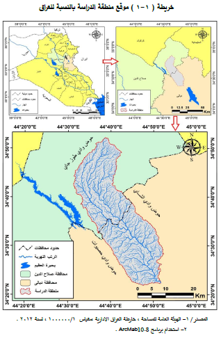
تهدف هذه الدراسة إلى تقدير حجم الجريان السطحي لحوض وادي الشنشال، الذي يقع في الجزء الشرقي من العراق ضمن الحدود الإدارية لمحافظتي صلاح الدين و ديالى ، ويقع فلكياً بين دائرتي عرض (52'00" ْ34 _ 24'0" ْ34) شمالاً وخطي طول (00'51" ْ45 _ 00'24" ْ44) شرقاً، تكتونياً تقع منطقة الدراسة ضمن الرصيف غير مستقر ضمن نطاق الطيات الواطئة (حزام حمرين) يتصف الحوض بالانحدار البسيط حسب تصنيف زنك (Zink) أما من حيث الارتفاع فقد قسم الحوض إلى خمس مستويات أقصى ارتفاع (354) م في حين كان أدنى ارتفاع (102) م صنفت الترب في منطقة الدراسة إلى خمس أصناف بالاعتماد على تصنيف بيورنك لتربة العراق ، تم الاعتماد على مؤشر (NDVI) لإعطاء صورة عن كثافة الغطاء النباتي في الحوض وذلك باستخدام المرئية الفضائية للقمر (Land sat 9) لمعرفة مدى تأثيره على سرعة الجريان السطحي .
تم إجراء تحليل للخصائص المورفومترية في منطقة الدراسة وذلك لاستخراج شبكة التصريف النهري ، إذ بينت الدراسة أن حوض الشنشال من التربة السادسة بحسب تصنيف (Strahlar) ، في حين أظهر نتائج التحليل الهبسومتري أن حوض وادي الشنشال وأحواضه الثانوية جميعاً تمر في مرحلة الشيخوخة من دورتها الجيومورفولوجية.
هيدرولوجيا تم احتساب الجريان المائي وفق النموذج الامريكي (SCS-CN) وبينت الدراسة مدى التباين بين هذه الأحواض في خصائصها الهيدرولوجية من حيث قيم منحنى الجريان (CN) إذ بلغت أقل قيمة في (حوض 8) إذ بلغت (70.84) وأعلى قيمة في (حوض 1) إذ بلغت (85.36) حيث تعد قيم مرتفعة مما يعطي انطباع أن هناك احتمالية لحدوث جريان مائي سطحي مرتفع في منطقة الدراسة.
دلت نتائج الدراسة إلى إمكانية تطبيق نظام حصاد مائي في المنطقة ، من خلال اختيار مواقع السدود المقترحة بهدف خزن المياه أو الإستفاده منها في مدد الجفاف ولمختلف الاستعمالات ، إذ تم تحديد ثلاث مناطق مثلى لحصاد المياه والإستفادة منها في تنمية الأراضي الزراعية ، وتوسيع المراعي ، وإقامة المستقرات البشرية ورفع مناسيب المياه الجوفية .

Abstract
This study aims to estimate the volume of surface runoff of the basin of Wadi Al-Shensal, which is located in the eastern part of Iraq within the administrative borders of the governorates of Salah al-Din and Diyala, and is located astronomically between the two latitudes. (ْ34 24'00 -34 ْ52'00") To the north and longitudes (ْ 44 ْ 24 '00" - 45°51'00")to the tectonic east, the study area is located within an unstable pavement within the range of the folds (Hamrin belt). The basin is characterized by a slight slope according to the classification of zinc.
In terms of height, the basin was divided into five levels, the maximum height was (354 m), while the lowest height was (102) m. The soils in the study area were classified into five categories based on Bjornck classification of Iraqi soil, the (NDVI) indicator was used to give a picture of The density of vegetation cover in the basin by using the satellite imagery (9 Land sat) to find out the extent of its effect on the speed of surface runoff.
An analysis of the morphometric characteristics was conducted in the study area in order to extract the river drainage network, as the study showed that the Al-Shenshal basin is of the sixth rank according to the classification (Strahlar), while the results of the hypsometric analysis showed that the Al-Shenshal basin and its secondary basins are all undergoing the aging phase of its geomorphological cycle.
Hydrology The water flow was calculated according to the American model (SCS-CN) and the study showed the extent of variation between these basins in their hydrological characteristics in terms of the values of the flow curve (CN), as it reached the lowest value in (Basin 8), which amounted to (70.84) and the highest value in (Basin 1 ) It reached (85.36), which are considered high values, which gives the impression that there is a possibility of high surface water flow in the study area.
The results of the study indicated the possibility of applying a water harvesting system in the region, by choosing the proposed dam sites in order to store water and benefit from it in the number of droughts and for various uses. ground water levels.
0 تعليقات
شكرا لتعليقك .. سيتم الرد عليكم في اقرب وقت ممكن .
كوكب المنى