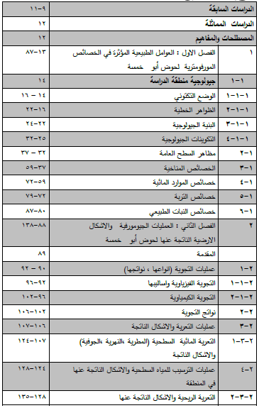
الخصائص المورفومترية لحوض أبو خمسة غرب
النجف وأثرها في النشاطات البشرية
رسالة مقدمة إلى كلية التربية للبنات بجامعة الكوفة
كجزء من متطلبات درجة الماجستير في الجغرافية
من قبل
وفاء حميد حسن الفتلاوي
بإشراف
الأستاذ الدكتور
عايد جاسم حسين الزاملي
The Morphometeric Characteristics
of Abu-Khamsah Basin to the West of and its impacts on human activities
A Thesis
Submitted to the Council of Faculty of
Education for Girls - University of Kufa
In Partial Fulfillment of the Requirements
for the Master Degree of in Geography
By
Wafaa Hameed Hasan Al-Fatlawy
Supervised by :-
Prof Dr .Ayyed Jasim Hussein Al-Zamili
Januaru 2019 A.D - Jumada Al-awwal 1440 A.H
Abstract
The study aimed to reveal the variation of the morphometric characteristics of Wadi Abu Khamesh basin in the west of Al-Najaf. The study area was divided into three secondary basins. The study included analysis of the spatial, morphological and surface characteristics of the valleys. The study concluded that the correlation between hydrological and morphometric variables between these characteristics and human activity. The study area is located within the lower valleys and stones of the stable and untwisted region between the two latitudes ( 31 22 00 -31 58 45) north and longitude (43 17 00 -44 12 00) east, with an area of (822.18) km2 , to the West of the province of Al-Najaf between Al-Rihaymawy basin on the north and Al- Malih basin on the south. The study found that the most ancient rocks and sediment belongs to the Eocene era. Its structure located within the stable shelf, Al- Najaf scope and the block of Salman affected by all the tectonic movements experienced by the region, which resulted in a series of cracks( 7 cracks) that affected the direction of the study area basins. The surface of the study area is a slight slope (2.9 m / km) in a southwestern direction to the northeast. The study area is characterized as a dry area within the region, The dry climate, which is more evapotranspiration on the precipitation and the temperature varies between summer and winter. It has seasonal rainfall and the Northwest winds predominate. Its hydrological characteristics are characterized by surface water which depends on the falling rain and groundwater. According to their physical and chemical properties, as demonstrated by the characteristics of natural plant and its types, the geomorphological processes, including the weathering processes and their effect on the formation of the earth shapes of the natural properties referred to, The analysis of the properties of the ponds in the study area analyzed morphometric. It was found that the ponds passed through the youth phase. Therefore, the concentration and flow equations were applied and compared with the measurement of the water flow volume of the basin of the study area .
The classification of the lands of the study area according to the geological criteria of the soil and soil form and divided the vegetation cover into lands (agricultural, saline, wet, rock, spaghetti, and barren). Hydrological soils were classified into three types. Depth and concentration of flow in the basin, and then addressed the natural potentialities that can be used represented by the natural resources of surface and groundwater and agricultural activity, natural plants and pastoralism and human settlements , investment of natural resources, the extent of exploitation through the rehabilitation of transport routes and interest in the tourist aspect.
تحميل الرسالة
كوكب المنى للنشر


0 تعليقات
شكرا لتعليقك .. سيتم الرد عليكم في اقرب وقت ممكن .
كوكب المنى