تقدير الجريان السطحي وأخطاره السيلية
في حوض وادي المحمدي بالعراق
باستخدام تقنيات
الاستشعار عن بعد و نظم المعلومات الجغرافية
رسالة مقدمة لنيل درجة الدكتوراه في الجغرافيا الطبيعية
إعداد الطالب
محمد موسى حمادي
إشراف
أ.د عبد العزيز عبد اللطيف يوسف
أستاذ الجغرافيا الطبيعية
كلية الآداب جامعة عين شمس كلية
أ.د محمد محمود طه
أستاذ الجغرافيا الطبيعية المساعد
الآداب جامعة عين شمس
القاهرة
1436ه - 2015م
Estimating runoff and Flash Flood Hazards in the basin valley Mohammadi Iraq Using remote sensing techniques and Geographic Information Systems
A Thesis
submitted for Ph.D. in Physical Geography
Prepared by
Mohammed Mousa Hammadi
Supervised by
Prof. Abdul Aziz Abdul Latif Yousef
Professor of Physical Geography
Faculty of Arts, Ain Shams University
Prof. Mohammed Mahmoud Taha
Professor of Physical Geography
Faculty of Arts, Ain Shams University
Cairo
2015
ABSTRACT
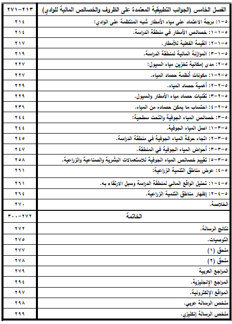
Al-Muhammadi valley is one of the important which is located in the lower valleys of the Iraqi western plateau, which has witnessed an increasingly urban growth during the few recent years. The area of its basin is 2309,1 km2 and its length is 93,6 km. This basin is a subject to frequent dangerous torrent, which led to many damages from many aspects. Therefore, this study aims at estimating the surface runoff and its torrent danger in the basin of Al-Muhammadi valley through implementing remote sensing and GIS in building a database with different variants which help in making advanced spatial analysis to come up with quick, accurate and variant results, as compared with the traditional methods. This study divided into five chapters preceded by the introduction and followed by the conclusions, recommendations, bibliography and appendices. The introduction comprises the importance of the study, the problems, review of literature, the aim of the study and its methodology, and the water crisis in Iraq. The first chapter deals with the natural features of the area of the study through the location, the geology of the area, its topography, its climate, soil and natural plants. Chapter two displays the morphometric features, including the cadastral and morphological and relief features of the basins. Besides, it includes the features of the drainage net and its patterns, the correlation matrix and factor analysis. Chapter three studies the hydrological features of the drainage basins through the analysis of the hydrological features which influence the occurrence of the torrents, the hydrological level of the drainage basins, estimating the danger of the valleys, and classifying the drainage basins according to the danger they pose according to net flow, regression rate and the dimensions affected area, and then finding the total ration to the sum of the variants which influence the danger of the basins under the study. Chapter four tackles the torrents and their danger through defining them, their historical record, 300 the factors that lead to their occurrence, their destructive impact, and determining the validity of use for human activities and the methods of limiting their dangers and making use of the water of the torrents. Chapter five studies the application aspects which depend on the water circumstances and features the valley. It also tackles the reliance on the water of the semi-regular rains in the valley, and the possibility of storing this water, and the features of the groundwater and subsurface water, and showing the areas of agricultural development.
تحميل من
↲ top4top
↲ mega.nz


0 تعليقات
شكرا لتعليقك .. سيتم الرد عليكم في اقرب وقت ممكن .
كوكب المنى