هيدرولوجية نهر الشافي في محافظة البصرة
رسالة تقدم بها
أسعد جواد كاظم السوداني
إلى مجلس كلية التربية للعلوم الإنسانية جامعة البصرة –
وهي جزء من متطلبات نيل درجة الماجستير
في الجغرافيا
بإشراف
الأستاذ الدكتور
حمدان باجي نوماس
1439 ه - 2018 م


Hydrology of the Shafi River
in Basrah province
A Thesis Submitted by
Asaad Jawad Kazem Al-Sudani
To The Council of College of Education for Human Sciences, University of Basrah in Partial fulfillment of the Requirements for the Degree Masters of Arts in Geography
Supervised by
Professor Dr.
HAMDAN B. NOMAS
1439 A.H - 2018A.D

Abstract
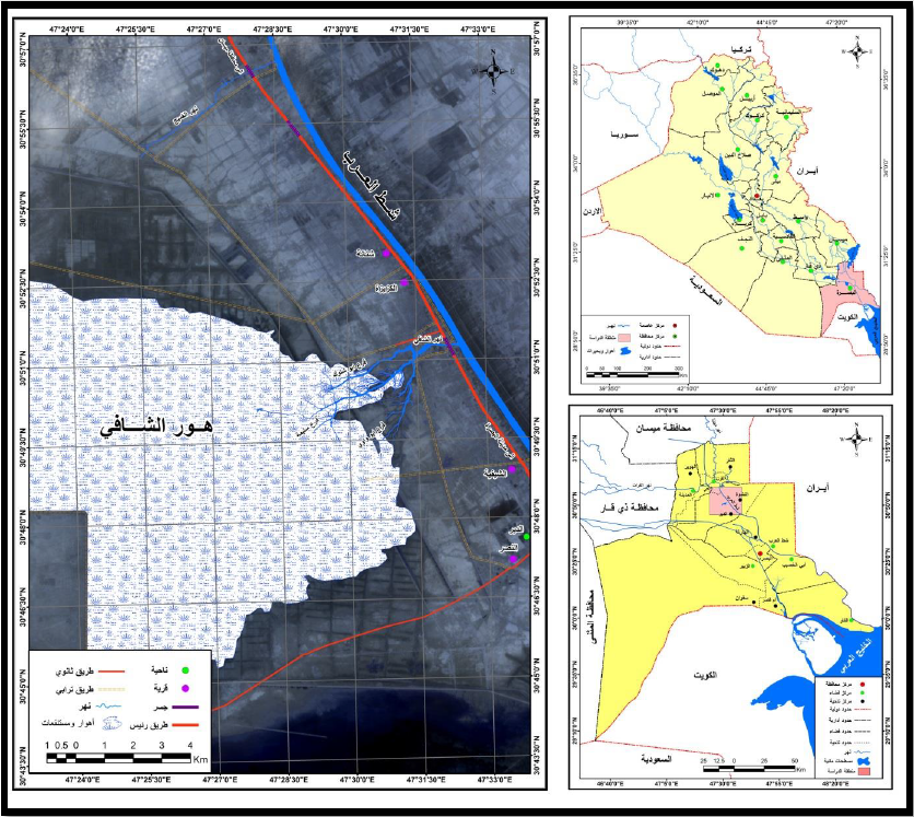
The present study deals with the hydrology of al-Shafi river in Basra, the south of Iraq. This river is astronomically located between the Latitudes (20.57- 20.40) north and Longitudes of (47.40-47.34) of the east. Its area is 305 km2 in 2017. The river lies about 3 km to the north of al-Dair district 19 km to the south of the Euphrates and Tigris rivers junction Qurna twon, between Al-Ghumaij river and the twon of Imam Qaaim at the north, from the south, the road of west field of Qurna (1) Shatt-al Arab river from the east and from the west by the dam constvucted by ministry of Irrigation.
The period of study is from 1\11\2016 to 1\10\2017 during which data have been collected starting from the water samples of six sites (12 samples during the ebb and flow period during summer and 12 samples during winter). Transverse samples Shatt al Arab have been taken at the spot of Al-Shafi river flow in addition to several spots chosen from this river using ADCP as a tool. four to the seasons in the year, two observations in each season and during 12 hrs for each observation have been done. TO recognize the hydro-chemical system of the river, measurements of speed and the height of ebb and flow have been taken, as well as soil samples chosen from six sites to get the level of salinit, acidity and texture to support the data via dense spatial checking that exceeds 20 samples during the period of study.
The results of study can be summarized as follows. Natural factors such as and climatic factors are affecting the hydrology of this river by controlling the rising level of this river topography The soil is porous .the shortage of raining that reaches 136 mm is for(1990-2015), the increased ratio of evaporation (3244,4 mm). These makefor the climatic balance negative during all months of the year. Also the human factors have an effect through controlling the imports of Shatt-al Arab by projects constuction irrigation(Turkey, Syria and Iran). This results in a decrease of Euphrates and Tigris water supply Karun rivers from Shatt al Arab. and Shafi river during the period of the of the 20th century, were made dried and changing that place into a planting project which was destined to be failed for the increase in the salt level in of soil. And during 2003, The area flooded again and Al shafi has recovered. The Shafi river of hydrology is affwcted by Shatt al Arab especially when the latter is suffering from severe ebb and flow moments that affect the Al Shafi River.
It reached the highest discharge of the Shafi River during the spring season (April). During the spring period of 18.3 m3 / s. The highest net discharge during the summer season (July) was 54.7 m3 / s due to increased evaporation and human activities. The annual rate of tidal drainage and net discharge was 15.2, 12.2 and 3 m3 / s. Respectively, at an annual rate of 0.09 m / s. The quality of water in the region coincided with the nature of the Shafi River through the increase of ion concentrations during the winter season due to the lack of drainage and rain works to wash the surface layer of the soil and its contents and elements of different concentrations to the river, as well as the lack of qualitative concentrations of water during the summer due to increased discharges Which reduces the concentration of concentrations, as well as the elements showed their decline during the period of the tide and rise during the period of the islands, which is due to the affected water of the Shafi river water stagnant stagnant water, and rising concentrations of water starting from the Shafi River, 1 channel SiO 2, respectively.
The quality of water in the Shafi River showed its validity for human, industrial and agricultural uses. The water quality of the sites (Shafi-2-Shafi-1-Hoor Al- Shafi) recorded their lack of validity for most of the human and environmental .uses of the high concentrations of physical and chemical ions studied.
The study area has several water components for the establishment of tourism, recreational and scientific projects and nature reserves, as well as its inclusion within the Ramsar Convention on Wetlands.
🔻
0 تعليقات
شكرا لتعليقك .. سيتم الرد عليكم في اقرب وقت ممكن .
كوكب المنى