حصاد مياه الأمطار
في وادي المر - محافظة نينوى - شمال العراق
RAIN WATER HARVESTING FOR Al MURR VALLY / NINAVA GOVERNARATE / NORTH IRAQ
عادل علي بلال
يسرى طه عبد الباقي
بشار منير الشكرجي
المستخلص:
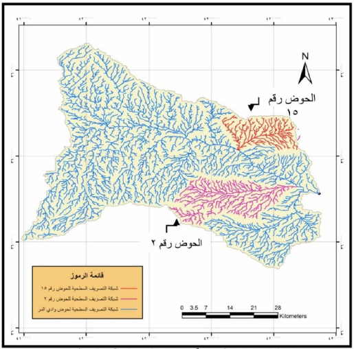
يهدف البحث إلى تقدير الجريان السطحي بالاعتماد على قيم العواصف المطرية المنفردة والذي يحسب كخطوة أولى في حصاد مياه الأمطار للمساهمة في معالجة شحة المياه بالإدارة المناسبة لمصادر المياه السطحية كالأمطار. وكذلك إيجاد الخصائص الهيدرومورفومترية لحوض وادي المر والذي يقع شمال غرب العراق ضمن محافظة نينوى وتبلغ مساحته الكلية (2469كم2). تم اختيار أفضل وأنسب المواقع لإنشاء سدود مقترحة لخزن مياه الأمطار. اعتمدت طريقة SCS المطورة لتخمين عمق السيح السطحي لمنطقة الدراسة وأخذت بنظر الاعتبار متغيرات مهمة في الجابية كنوع التربة واستعمال الأرض والرطوبة المسبقة للتربة، واستخدمت تقنية نمذجة الأحواض المائية (WMS) والصور الفضائية والخرائط الرقمية ونموذج الارتفاع الرقمي (DEM) لمحاكاة وتحليل البيانات الهيدرولوجية وتحديد افضل المقاطع لمواقع السدود المقترحة لخزن المياه. اعتمدت بيانات الأمطار اليومية للمدة (2003-2012) لمحطة ربيعة لغرض تقدير الجريان السطحي وقسم الحوض الرئيسي إلى خمسة عشر حوض ثانوي ووجد أن هناك حوضين (2،15) يمثلان أفضل الأحواض الثانوية لحجز المياه واختير أنسب موقعين في نهاية كل حوض ليكون الموقع المقترح لإنشاء سد بارتفاع خمسة أمتار وليحجز مياه تقدر بـ (820830)م3 و(668323) م3 للحوضين الثاني والخامس عشر على التوالي. بلغ معدل الساقط المطري للمدة أعلاه (297) مم وتراوح عمق السيح السطحي السنوي لمنطقة الدراسة بين (2.17-46.2)مم وظهر أن العواصف المطرية خلال (2007- 2008) و(2011-2012) لم تنتج أي سيح سطحي.
Abstract
The paper aims to estimate runoff based on the values of single storm which is calculated as a first step for water harvesting to contribute water scarcity and management of surface water resources, as well as to find morphometric properties of Almurr basin .The Basin is located north-west of Iraq in the province of Nineveh, with a total area (2469 km 2). Dams were proposed, chosen in the best and most suitable sites to store rain water. SCS developed method adopted to estimate the depth of surface runoff for the study area, taking into consideration the important variables as, soil type, land use and antecedent moisture content (AMC).watershed Modeling system (WMS) Technique, satellite images, digital maps and digital elevation model (DEM) were used to simulate and analyze hydrological data and to determine the best sections of the proposed dams sites. Data of daily rains of Rabiaa station of the period (2003-2012) were adopted for the purpose of estimating runoff. Almurr basin was divided into fifteen Sub basins. The (2 and 15) Sub basins were found to be the best water harvesting. Consequently, most suitable locations were selected at the end of each these two sub basins as the proposed site for the construction of a dam of five meters height. The reserved water estimated at (820 830) m3 and (668323) m3 for the two sub basins respectively. The mean rainfall for the above period reached (297) mm and the depth of surface runoff between (2.17and 46.2) mm. The rainstorms during (2007-2008) and (2011-2012) did not produce any surface runoff.


للتحميل اضغط top4top
للقراءة و التحميل اضغط iasj
0 تعليقات
شكرا لتعليقك .. سيتم الرد عليكم في اقرب وقت ممكن .
كوكب المنى